Extreme Weather News

Jump to a Year

2024 | 2023 | 2022 | 2021 | 2020

2019 | 2018 | 2017 | 2016 | 2015

2014 | 2013 | 2012 | 2011 | 2010

2009 | 2008 | 2007 | 2006 | 2005

2004 | 2003 | 2002

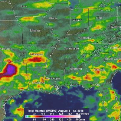
NASA's IMERG Estimates Of Rainfall Over The Eastern United States

Most of the Eastern half of the United States had rainfall during the past week. Some parts of the country experienced heavy rainfall that resulted in flash floods and various other problems. Slow-moving storm systems and nearly stationary fronts were the cause of heavy rainfall over Virginia this past weekend. Several trees were brought down by a severe storm that hit Fredericksburg, Virginia Sunday Afternoon. Fallen trees blocked several roads, flash flooding occurred and electrical power was lost in that area. Continuing heavy rain also fell in Texas over the weekend. This provided some

GPM Passes Over Weakening Hurricane John

The GPM core observatory satellite provided very good coverage of hurricane JOHN when it passed above the eye of the tropical cyclone on August 8, 2018 at 0:59 AM MDT (0659 UTC). JOHN's maximum sustained wind speeds had started to decrease. GPM's Microwave Imager (GMI) and Dual-Frequency Precipitation Radar (DPR) instruments showed that most of JOHN's precipitation was then located in the eastern half of the hurricane. A large cloud free area had developed between the center of the hurricane and an intense feeder band wrapping around the northern and western side of the hurricane. GPM's radar

GPM Views Tropical Storm John

The GPM core observatory satellite had an extremely good view of tropical storm John on August 6, 2017 at 1:08 AM MDT (0708 UTC). The satellite passed right over John's center of circulation. GPM's Microwave Imager (GMI) and Dual-Frequency Precipitation Radar (DPR) instruments provided excellent coverage of precipitation associated with tropical storm John. GPM showed that the large tropical cyclone was becoming well organized and had intense rainfall within feeder bands that were spiraling toward John's center. GPM's radar (DPR Ku Band) revealed that a band of powerful storms northeast of

GPM Sees Tropical Storm Hector Forming

Tropical storm Hector was forming in the eastern Pacific Ocean southwest of Mexico when the GPM core observatory satellite passed over on July 31, 2018 at 1:40 PM PDT (2040 UTC). Hector's maximum sustained winds at that time were estimated to be about 30 kts (34.5 mph). Powerful convective storms were wrapping around the western side of the deepening tropical low's center of circulation. GPM's Dual-Frequency Precipitation Radar (DPR) instrument collected data showing that rain in some of these storms was falling at a rate of almost 198 mm (7.8 inches) per hour. The GPM satellite's radar data