Extreme Weather News

Jump to a Year

2024 | 2023 | 2022 | 2021 | 2020

2019 | 2018 | 2017 | 2016 | 2015

2014 | 2013 | 2012 | 2011 | 2010

2009 | 2008 | 2007 | 2006 | 2005

2004 | 2003 | 2002

GPM Probes Tropical Storm Maliksi

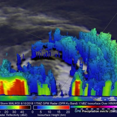
The GPM core observatory satellite had an excellent view of tropical storm MALIKSI when it passed over southern Japan on June 10, 2018 at 1759 UTC. GPM's Microwave Imager (GMI) and Dual Frequency Precipitation Radar (DPR) instruments collected data that revealed the horizontal and vertical extent of precipitation within the tropical storm. GPM's GMI showed that heavy downpours were occurring in a rain band wrapping around MALIKSI's northeastern side. GPM's radar (DPR Ku Band) found that bands of storms moving around the northwestern side of the tropical storm were dropping rain at a rate of

GPM Flies Over Intensifying Hurricane Aletta

As expected, tropical storm Aletta intensified and became a hurricane. Aletta was a powerful hurricane with winds of about 85 kts (98 mph) when the GPM core observatory satellite passed over head on June 7, 2018 at 18:38 PM MDT (June 8, 2018 at 0038 UTC). GPM's Microwave Imager (GMI) and Dual Frequency Precipitation Radar (DPR) instruments showed that hurricane Aletta contained powerful storms that were producing heavy precipitation. Very strong convective storms were producing heavy rainfall in Aletta's eye wall while the most extreme downpours were shown in a large feeder band wrapping

Tropical Storm Aletta Forms In Eastern Pacific

Early today Tropical Depression Two-E was upgraded to tropical storm Aletta. This is the first tropical storm of the 2018 eastern North Pacific season. Aletta was located well southwest of Mexico. The National Hurricane Center (NHC) predicts that Aletta will become a hurricane tomorrow as it moves westward over the open waters of the eastern North Pacific ocean. The GPM core observatory satellite passed above developing tropical storm Aletta on June 6, 2018 at 0046 UTC. This image shows precipitation measurements that were calculated from data collected by GPM's Microwave Imager (GMI) and Dual

Two Cyclones Hit Somalia and Oman Within a Week

The first cyclone to strike the area, Sagar, formed from an area of thunderstorm activity located in the western Arabian Sea south of the island of Socatra. The area of low pressure associated with the thunderstorms first moved northwest into the far eastern Gulf of Aden, where it intensified into a minimal tropical storm with sustained winds estimated at 35 knots (~40 mph) by the Joint Typhoon Warning Center (JTWC), before turning west and then southwest down the middle of the Gulf. As it moved down the Gulf, Sagar slowly strengthened into a stronger tropical storm with sustained winds

Alberto Makes Landfall, Brings Heavy Rains to Parts of the Southeast and Tennessee Valley

Alberto formed out of a broad area of low pressure at the surface that was located over and around the Yucatan Peninsula. Because the area of low pressure was under the influence of a nearby upper-level trough, Alberto was designated as a subtropical storm by the National Hurricane Center (NHC) on the morning of Friday May 25th, which is rather unusual as most subtropical storms form at higher latitudes. The storm initially formed just east of the Yucatan Peninsula. A large subtropical ridge over the southwestern Atlantic steered Alberto on a northward track, and the storm brushed the far