GPM Examines Forming Subtropical Storm Alberto
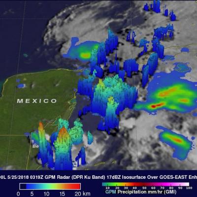
At 10:00 AM CDT today the National Hurricane Center (NHC) upgraded low pressure center (90L) to Subtropical Storm Alberto. Alberto moved over the waters of the northwestern Caribbean Sea. Alberto is expected to bring heavy rainfall and flash flooding to the northeastern Yucatan, western Cuba and Florida over the Memorial Day weekend. The GPM core observatory satellite passed above the Yucatan Peninsula on May 24, 2018 a 11:19 PM EDT (May 25, 2018 at 0319 UTC). With this pass GPM saw areas of heavy precipitation within the western Caribbean and in the Gulf Of Mexico west of Cuba. GPM's Dual