Extreme Weather News

Jump to a Year

2024 | 2023 | 2022 | 2021 | 2020

2019 | 2018 | 2017 | 2016 | 2015

2014 | 2013 | 2012 | 2011 | 2010

2009 | 2008 | 2007 | 2006 | 2005

2004 | 2003 | 2002

Tropical Cyclone Ava's Disastrous Rainfall Measured With IMERG

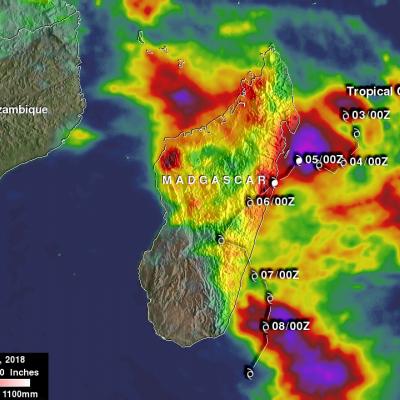
Tropical cyclone Ava dropped extremely heavy rainfall over Madagascar as it passed over the eastern side of the island country from January 5-6, 2018. Ava's drenching rainfall caused flooding and landslides which resulted in the deaths of at least 29 people. An estimated 80,000 people on Madagascar were affected by the tropical cyclone. This rainfall analysis was produced by accumulating rainfall that fell near Madagascar during the period from January 2-8, 2018. These IMERG estimates showed the locations of extreme rainfall totals during the period when tropical cyclone Ava was in Madagascar

Powerful Tropical Cyclone Irving Examined With GPM

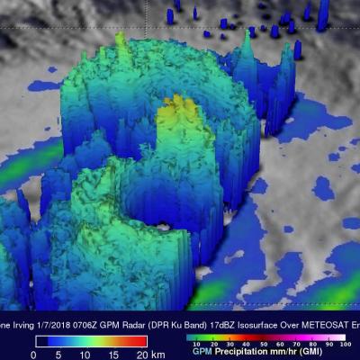
Tropical cyclone Irving formed in the South Indian Ocean on January 6, 2018. Irving posed no threat to land because it orgininated over the open ocean far to the west of Australia. GPM's core observatory satellite had an excellent view of Irving's eye on January 2018 at 0706Z. The well defined rainfall patterns within Irving were clearly shown by GPM's Microwave Imager (GMI) and Dual Frequency Precipitation Radar (DPR) data. Very heavy rainfall was shown in the western side of Irving's large eye wall. GPM's Radar (DPR Ku Band) found rain in that side of the tropical cyclone falling at a rate

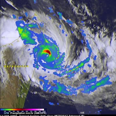
Tropical Cyclone Ava Viewed By GPM

Tropical cyclone AVA formed in the southeast Indian Ocean northeast of Madagascar on January 2, 2018. AVA became increasingly powerful and approached the eastern coast of Madagascar with maximum sustained winds estimated to be greater than 90 kts (103.5 mph). AVA has been interacting with land and wind speeds near Tamatave, Madagascar have been reported to be 70 kts (80.5 mph). The Joint Typhoon Warning Center (JTWC) predicts that tropical cyclone AVA will move to the south along Madagascar's eastern coast for a day or so and then return to the Indian Ocean. Very heavy rainfall is expected to
GPM Sees Powerful Winter Storm Grayson
Powerful Coastal Storm Brings Snow, Extreme Cold, Wind and Blizzard Conditions to the East Coast View an interactive 3D visualization of GPM data from Winter Storm Grayson in STORM Event Viewer Mobile version Cold Artic air has been keeping the vast majority of the country east of the Rockies in the deep freeze over the past week. Now a powerful coastal storm is working its way up the East Coast bringing a mixture of snow, freezing rain, high winds and blizzard conditions from as far south as Florida all the way up into Maine with blizzard warnings in effect along the coast from North Carolina...

GPM Finds Heavy Rain In Short Lived Tropical Cyclone Hilda

Tropical cyclone HILDA formed very close to Australia's northwestern coast on December 27, 2017 at 1800 UTC and dissipated quickly as it crossed over land. The GPM core observatory satellite had a good view of the short lived tropical cyclone on December 27, 2017 at 2031 UTC. A red tropical storm symbol shows HILDA's approximate location when GPM passed above. The center of GPM's coverage was mainly east of HILDA's center of circulation. The intensity of rainfall in a large intense band of storms wrapping around the northeastern side of the tropical cyclone was measured by the satellite's